19KM RACE DETAIL
9:00AM START (Tai Tam BBQ Area Site 2)
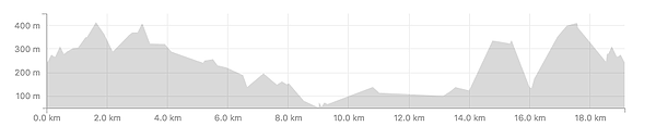
19km / 1,142m of elevation
The race start and finish area is at Tai Tam BBQ Area Site 2 on Tai Tam Reservoir Road next to Parkview.
Easiest access is via cab to the Parkview entrance on Tai Tam Reservoir Road. BBQ site 2 is a 5-10 minute walk down the hill towards Tai Tam Reservoirs, and directly opposite the public toilets at the bottom of the hill.
Buses go to the gas station on Wong Nei Chung Gap Road and it is a solid 25 minute walk up the hill to Parkview and the start/finish area from there.
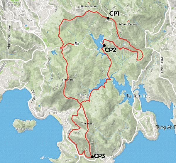
Start > Jardines Lookout > Mt Butler > CP1 Windy Gap (4km) > Wilson Trail > CP 2 Mt Parker/Tai Tam Dam (8km) > Tai Tam Intermediate Reservoir Trail > Twins Catchwater > CP3 Base of Twins (14km) > The Twins > Violet Hill > Finish at Tai Tam BBQ Area
View Strava route info here (GPX available)
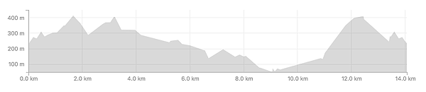
14KM RACE DETAIL
9:00AM START (Tai Tam BBQ Area Site 2)
14km / 881m of elevation
The race start and finish area is at Tai Tam BBQ Area Site 2 on Tai Tam Reservoir Road next to Parkview.
Easiest access is via cab to the Parkview entrance on Tai Tam Reservoir Road. BBQ site 2 is a 5-10 minute walk down the hill towards Tai Tam Reservoirs, and directly opposite the public toilets at the bottom of the hill.
Buses go to the gas station on Wong Nei Chung Gap Road and it is a solid 25 minute walk up the hill to Parkview and the start/finish area from there.
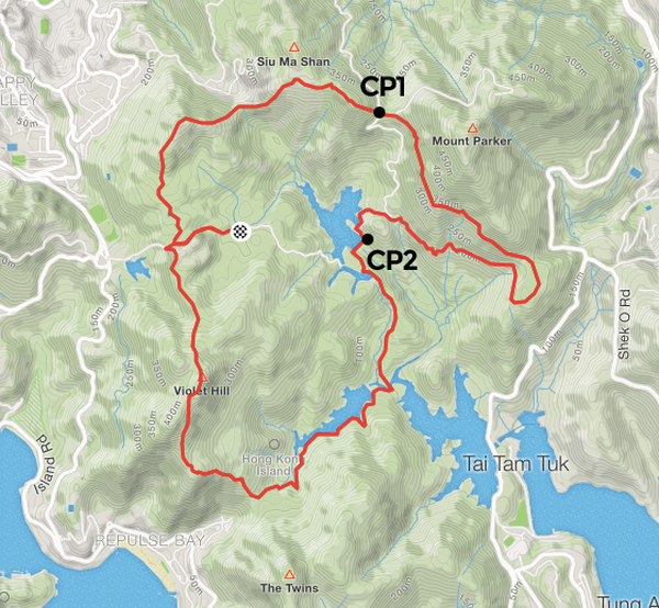
Start > Jardines Lookout > Mt Butler > CP1 Windy Gap (4km) > Wilson Trail > CP 2 Mt Parker/Tai Tam Dam (8km) > Tai Tam Intermediate Reservoir Trail > Violet Hill > Finish at Tai Tam BBQ Area
View Strava route info here (GPX available)
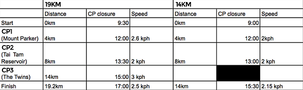
TIMING INFO